Exposure metadata

The exposure component is described as:

Metadata that is specific to datasets that describe the situation of people, infrastructure, housing, production capacities and other tangible human assets that might be located in hazard-prone areas.

The exposure component describes metadata for datasets containing information on the distribution and characteristics of built environment assets (buildings and infrastructure) and natural assets and population, that are used in risk assessment. The exposure component provides codelists to describe the type of assets and costs, and the taxonomy scheme that is used to describe construction and demographic information contained in the dataset. For more information, see exposure standards.

The exposure component uses exposure categories consistent with the vulnerability and loss components of this standard. Spatial reference and location information are described using existing external standards. Temporal information can include date and duration of events or year of scenario, and is defined using the Dublin Core standards.

Overview

            erDiagram
        Direction LR

        Exposure_item {
            string id*
            string category*
            object asset_type
        }

        Dataset ||--o{ "Exposure metadata": ""
        "Exposure metadata" o|--|{ Exposure_item: "Describes exposure of"
        Exposure_item o|--|{ "Metric": "Exposure quantified by"
    

Examples

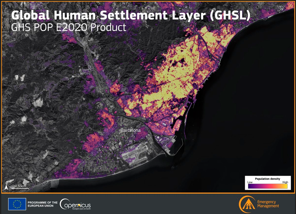
Example: GHSL Population map

The following example shows RDLS metadata for the GHSL Population map in JSON format.

../../../_images/figure.png
{
    "id": "rdls_exp_ghsl_global_hum_pop",
    "title": " GHS population grid multitemporal (1975-2030) ",
    "description": "The spatial raster dataset depicts the distribution of residential population, expressed as the number of people per cell. Residential population estimates between 1975 and 2020 in 5-year intervals and projections to 2025 and 2030 derived from CIESIN GPWv4.11 were disaggregated from census or administrative units to grid cells, informed by the distribution, volume, and classification of built-up as mapped in the Global Human Settlement Layer (GHSL) global layer per corresponding epoch. ",
    "risk_data_type": [
        "exposure"
    ],
    "publisher": {
        "name": "Copernicus",
        "url": "https://human-settlement.emergency.copernicus.eu/"
    },
    "version": "R2023",
    "project": {
        "name": "GHSL - Global Human Settlement Layer",
        "url": "https://human-settlement.emergency.copernicus.eu/"
    },
    "details": "This dataset is an update of the product released in 2022. Major improvements are the following: use of built-up volume maps (GHS-BUILT-V R2022A); use of more recent and detailed population estimates derived from GPWv4.11 integrating both UN World Population Prospects 2022 country population data and World Urbanisation Prospects 2018 data on Cities; revision of GPWv4.11 population growthrates by convergence to upper administrative level growthrates; systematic improvement of census coastlines; systematic revision of census units declared as unpopulated; integration of non-residential built-up volume information (GHS-BUILT-V_NRES R2023A); spatial resolution of 100m Mollweide (and 3 arcseconds in WGS84); projections to 2030.",
    "contact_point": {
        "name": "JRC GHSL",
        "email": "jrc-ghsl-data@ec.europa.eu",
        "url": "https://data.jrc.ec.europa.eu/dataset/2ff68a52-5b5b-4a22-8f40-c41da8332cfe"
    },
    "creator": {
        "name": "EC Joint Research Centre",
        "url": "https://human-settlement.emergency.copernicus.eu/ghs_pop2023.php"
    },
    "spatial": {
        "scale": "global"
    },
    "temporal": {
        "start": "1975-01-01",
        "end": "2030-12-31"
    },
    "license": "https://creativecommons.org/licenses/by/4.0/",
    "referenced_by": [
        {
            "author_names": [
                "Marcello Schiavina",
                "Sergio Freire",
                "Alessandra Carioli",
                "Kytt MacManus"
            ],
            "name": "GHS-POP R2023A - GHS population grid multitemporal (1975-2030)",
            "date_published": "2023-01-01",
            "url": "http://data.europa.eu/89h/2ff68a52-5b5b-4a22-8f40-c41da8332cfe",
            "doi": "10.2905/2FF68A52-5B5B-4A22-8F40-C41DA8332CFE",
            "id": "reference_YpnOc6ds"
        }
    ],
    "resources": [
        {
            "title": "GHS population grid (R2023)",
            "description": "The product is available for different epochs, resolutions and coordinate systems, but not all the combinations are available.",
            "access_url": "https://human-settlement.emergency.copernicus.eu/download.php?ds=pop",
            "media_type": "image/tiff;application=geotiff",
            "spatial": {
                "scale": "global"
            },
            "spatial_resolution": 90,
            "coordinate_system": "ESRI:54009",
            "id": "resource_wFzHZaaT"
        }
    ],
    "exposure": [
        {
            "metrics": [
                {
                    "id": "metric_r7kCCvfl",
                    "measurement": {
                        "quantity_kind": "count",
                        "unit": "count"
                    },
                    "dimension": "population"
                }
            ],
            "category": "population",
            "id": "item_QWMOqZs6"
        }
    ],
    "links": [
        {
            "href": "https://docs.riskdatalibrary.org/en/1__0__0/rdls_schema.json",
            "rel": "describedby"
        }
    ]
}
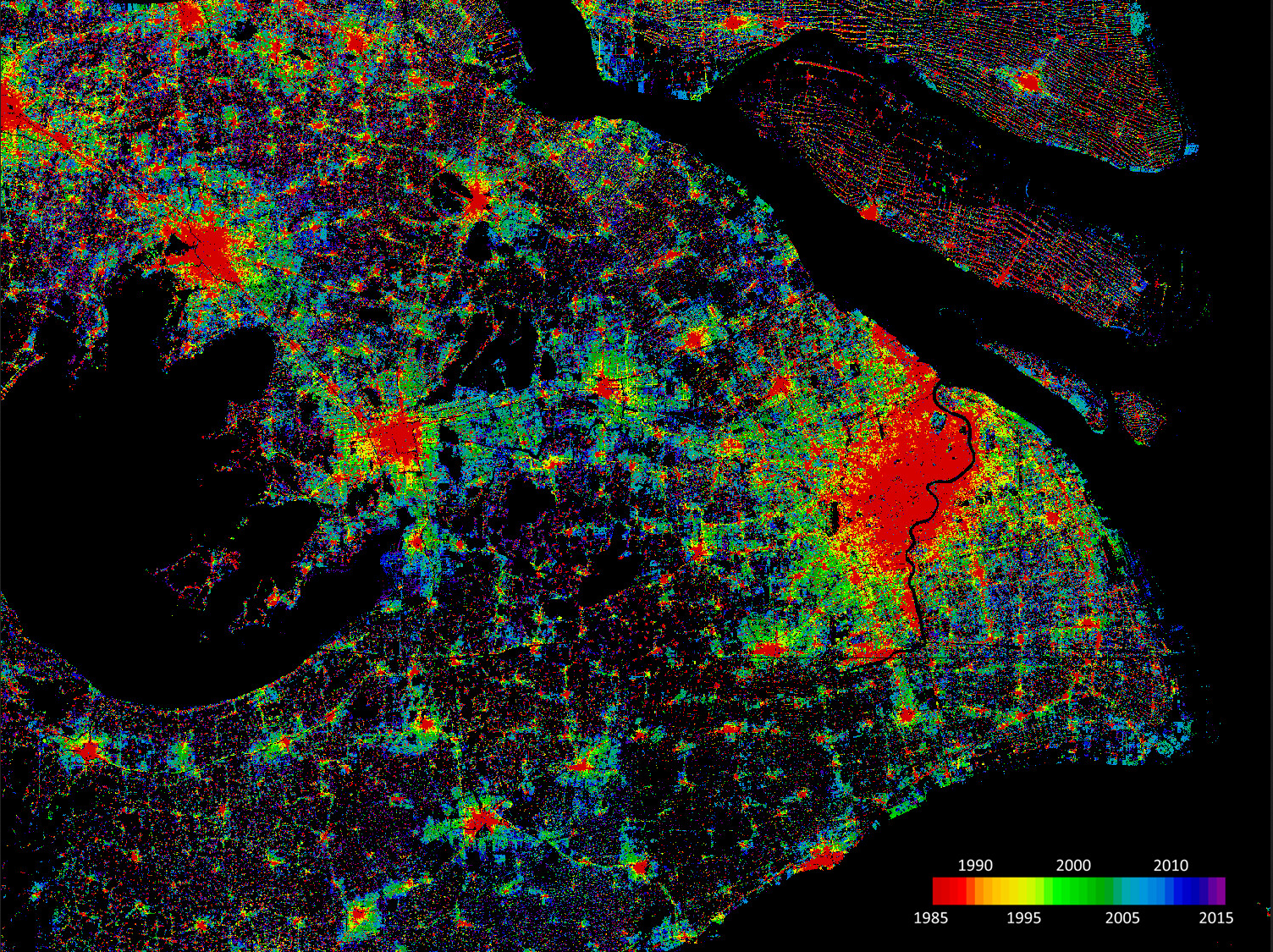
Example: World Settlement Footprint Evolution

The following example shows RDLS metadata for the World Settlement Footprint Evolution in JSON format.

../../../_images/figure1.png
{
    "id": "rdls_exp_world_settlemen_bld",
    "title": "World Settlement Footprint Evolution",
    "description": "The World Settlement Footprint (WSF\u00ae) Evolution is a 30m resolution dataset outlining the global settlement extent on a yearly basis from 1985 to 2015.",
    "risk_data_type": [
        "exposure"
    ],
    "publisher": {
        "name": "DLR",
        "url": "https://geoservice.dlr.de/"
    },
    "version": "R2019",
    "project": {
        "name": "World Settlement Footprint (WSF\u00ae)",
        "url": "https://www.dlr.de/en/eoc/research-transfer/projects-missions/world-settlement-footprint-wsf-r"
    },
    "details": "Based on the assumption that settlement growth occurred over time, all pixels categorized as non-settlement in the WSF2015 (Marconcini et al., 2020) are excluded a priori from the analysis. Next, for each target year in the past, all available Landsat-5/7 scenes acquired over the given area of interest are gathered and key temporal statistics (i.e., temporal mean, minimum, maximum, etc.) are then extracted for different spectral indices. Among others, these include: the normalized difference built-up index (NDBI), normalized difference vegetation index (NDVI) and modified normalized difference water index (MNDWI). Temporal features proved generally robust if computed over at least 7 clear cloud-/cloud-shadow-free observations; accordingly, if for a given pixel in the target year this constraint is not satisfied, the time frame is enlarged backwards (at 1-year steps) as long as the condition is met. Starting backwards from the year 2015 - for which the WSF2015 is used as a reference - settlement and non-settlement training samples for the given target year t are iteratively extracted by applying morphological filtering to the settlement mask derived for the year t+1, as well as excluding potentially mislabeled samples by adaptively thresholding the temporal mean NDBI, MNDWI and NDVI. Finally, binary Random Forest classification in performed. To quantitatively assess the high accuracy and reliability of the dataset, an extensive campaign based on crowdsourcing photointerpretation of very high-resolution airborne and satellite historical imagery has been performed with the support of Google. In particular, for the years 1990, 1995, 2000, 2005, 2010 and 2015, ~200K reference cells of 30x30m size distributed over 100 sites around the world have been labelled, hence summing up to overall ~1.2M validation samples. It is worth noting that past Landsat-5/7 availability considerably varies across the world and over time. Independently from the implemented approach, this might then result in a lower quality of the final product where few/no scenes have been collected. Accordingly, to provide the users with a suitable and intuitive measure that accounts for the goodness of the Landsat imagery, we conceived the Input Data Consistency (IDC) score, which ranges from 6 to 1 with: 6) very good; 5) good; 4) fair; 3) moderate; 2) low; 1) very low. The IDC score is available on a yearly basis between 1985 and 2015 and supports a proper interpretation of the WSF evolution product. The WSF evolution and IDC score datasets are organized in 5138 GeoTIFF files (EPSG4326 projection) each one referring to a portion of 2 x 2 degree size (~222 x 222 km) on the ground. WSF evolution values range between 1985 and 2015 corresponding to the estimated year of settlement detection, whereas 0 is no data. A comprehensive publication with all technical details and accuracy figures is currently being finalized. For the time being, please refer to Marconcini et al,. 2021.",
    "contact_point": {
        "name": "WSF team",
        "email": "wsf@dlr.de"
    },
    "creator": {
        "name": "Mattia Marconcini",
        "url": "https://www.linkedin.com/in/mattia-marconcini-820943218/"
    },
    "spatial": {
        "scale": "global"
    },
    "license": "https://creativecommons.org/licenses/by/4.0/",
    "referenced_by": [
        {
            "author_names": [
                "Mattia Marconcini",
                "Annekatrin Metz-Marconcini",
                "Thomas Esch",
                "Noel Gorelick"
            ],
            "name": "Understanding Current Trends in Global Urbanisation - The World Settlement Footprint Suite",
            "date_published": "2021-01-01",
            "url": "https://austriaca.at/0xc1aa5576%200x003c9b4c.pdf",
            "doi": "10.1553/giscience2021_01_s33",
            "id": "reference_06CerJZR"
        }
    ],
    "resources": [
        {
            "title": "World Settlement Footprint (WSF) Evolution 1985-2015",
            "description": "Binary mask at 10m resolution outlining the extent of human settlements globally derived by means of 2019 multitemporal Sentinel-1 (S1) and Sentinel-2 (S2) imagery.",
            "access_url": "https://geoservice.dlr.de/web/maps/eoc:wsfevolution",
            "download_url": "https://download.geoservice.dlr.de/WSF_EVO/",
            "media_type": "image/tiff;application=geotiff",
            "spatial_resolution": 30,
            "coordinate_system": "EPSG:4326",
            "temporal": {
                "start": "1985-01-01",
                "end": "2015-12-31",
                "duration": "P30Y"
            },
            "temporal_resolution": "P1Y",
            "id": "resource_NPEYfGyB"
        }
    ],
    "exposure": [
        {
            "metrics": [
                {
                    "id": "metric_BKBbYQVC",
                    "measurement": {
                        "quantity_kind": "area"
                    },
                    "dimension": "structure"
                }
            ],
            "category": "buildings",
            "id": "item_l0v4utD8"
        }
    ],
    "links": [
        {
            "href": "https://docs.riskdatalibrary.org/en/1__0__0/rdls_schema.json",
            "rel": "describedby"
        }
    ]
}

Properties

Title

Description

Type

Format

Required

id

string

Required

Exposure item identifier

A locally unique identifier for this exposure item.

category

string

Required

Exposure category

The category of the exposed assets, from the closed exposure_category codelist.

asset_type

object

Asset type

The type of asset

asset_type/scheme

object

None

The scheme or codelist from which the classification code is taken, using the open classification_scheme codelist. Use of GED4ALL is recommended.

asset_type/id

string

Required

Classification identifier

The classification code taken from the scheme.

asset_type/title

string

Title

A title for the classification code.

asset_type/description

string

Description

A description for the classification code.

asset_type/uri

string

iri

URI

A URI to uniquely identify the classification code.

metrics

array[Asset exposure metric]

Required

Exposure metrics

The measurements used to quantify the extent to which assets are exposed.

See Metric

Metric

Title

Description

Type

Format

Required

id

string

Required

Identifier

A locally unique identifier for this metric.

dimension

string

Required

Metric dimension

The dimension on which the asset’s exposure is measured, from the closed metric_dimension codelist.

measurement

object

Required

Metric measurement

How the metric is measured.

measurement/quantity_kind

string

Quantity kind

The kind of quantity by which it is quantified, from the open quantity_kind codelist.

measurement/unit

string

Unit

The unit by which it is measured, taken from the unit codelist for the quantity kind.

measurement/valuation_year

string

Valuation year

The year of the monetary valuation, expressed as a 4-digit year (YYYY). Applicable when quantity_kind is ‘currency’.