Vulnerability metadata
The vulnerability component is described as:
Metadata that is specific to datasets that describe the vulnerability relationships in relation to specific hazards, or geospatial indices associated with the chance of suffering losses from hazard events.
The vulnerability component describes metadata for datasets that detail relationships between hazard intensity and expected losses over exposed items, or spatial indexes associated with socio-economic vulnerability.
The function component uses hazard type, process type and intensity measure consistent with the hazard and loss components, exposure information consistent with the exposure and loss components. It contains key information including the type of function, intensity and impact metrics used, which asset types or population groups it applies to, how it was developed and for what locations. The spatial indices component uses indicator id, description and thresholds. Spatial reference and location information are described using existing external standards.
Overview
            erDiagram
        Direction LR

        "Vulnerability metadata" {
        }

        Dataset ||--o{ "Vulnerability metadata": ""
        "Vulnerability metadata" o|--o{ "Vulnerability function": "Used to calculate impact"
        "Vulnerability metadata" o|--o{ "Fragility function": "Used to calculate impact"
        "Vulnerability metadata" o|--o{ "Damage-to-loss function": "Used to calculate impact"
        "Vulnerability metadata" o|--o{ "Engineering demand function": "Used to calculate impact"
        "Vulnerability metadata" o|--o{ "Socio-economic indicator": "Used to calculate impact"
Examples
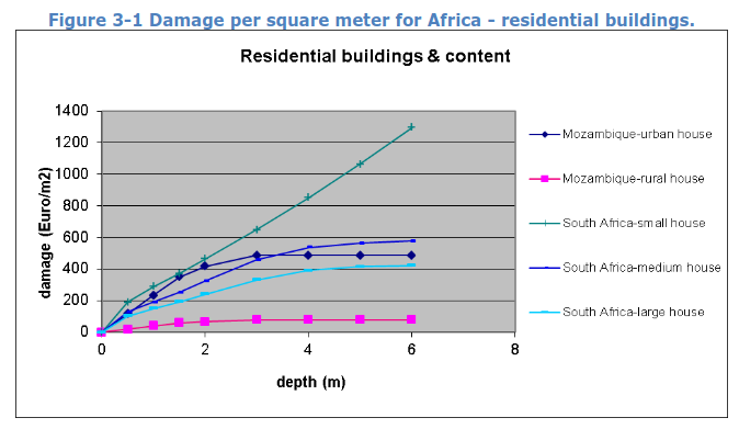
Example: Global flood depth-damage functions
The following example shows RDLS metadata for the Global flood depth-damage functions in tabular format and JSON format.
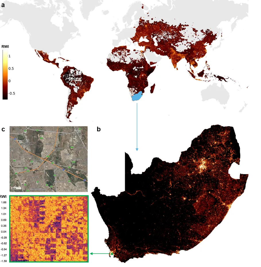
Example: Relative Wealth Index
The following example shows RDLS metadata for the Relative Wealth Index in JSON format.
Properties
Title |
Description |
Type |
Format |
Required |
|---|---|---|---|---|
functions |
object |
|||
Functions |
Details of the functions used to calculate the vulnerability dataset. |
|||
functions/vulnerability |
array[Vulnerability function] |
|||
Vulnerability functions |
The vulnerability functions used to calculate the impact of the hazard. |
|||
functions/fragility |
array[Fragility function] |
|||
Fragility functions |
The fragility functions used to calculate the impact of the hazard. |
|||
functions/damage_to_loss |
array[Damage-to-loss function] |
|||
Damage-to-loss functions |
The damage-to-loss functions used to calculate the impact of the hazard in conjunction with fragility functions. |
|||
functions/engineering_demand |
array[Engineering demand function] |
|||
Engineering demand functions |
The engineering demand functions used to calculate the impact of the hazard. |
|||
socio_economic |
array[Socio-economic Indicator] |
|||
Socio-economic indices |
Array of socio-economic indices vulnerable to the hazard. |
|||
Vulnerability function
Title |
Description |
Type |
Format |
Required |
|---|---|---|---|---|
id |
string |
Required |
||
Identifier |
A unique identifier for the function. Use of an HTTP URI is recommended. |
|||
approach |
string |
Required |
||
Approach |
The approach the function is based upon, taken from the closed function_approach codelist. |
|||
relationship |
string |
Required |
||
Impact relationship type |
The type of function relationships used to calculate the impact values, taken from the closed relationship_type codelist. |
|||
hazard_primary |
object |
|||
Primary hazard type |
The primary hazard involved in the modelled scenario(s). See Hazard |
|||
hazard_secondary |
object |
|||
Secondary hazard type |
The secondary hazard involved in the modelled scenario(s). See Hazard |
|||
hazard_analysis_type |
string |
|||
Hazard analysis type |
The type of analysis applied to the hazard data used in the modelled scenario(s), from the closed analysis type codelist. |
|||
category |
string |
|||
Exposure category |
The category of the exposed assets, from the closed exposure_category codelist. |
|||
impact |
object |
|||
Impact |
Information about how the impacts of hazards are calculated. |
|||
impact/type |
string |
|||
Impact type |
The type of impact calculated, taken from the closed impact_type codelist. |
|||
impact/modelling |
string |
|||
Impact modelling |
The type of data used to calculate the impact values, taken from the closed data_calculation_type codelist. |
|||
impact/metric |
string |
|||
Impact metric |
The metric used to describe the impact, taken from the open impact_metric codelist. |
|||
impact/loss_statistic |
string |
|||
Loss statistic |
The type of statistical summary applied to the loss values, from the closed loss_statistic codelist. |
|||
impact/measurement |
object |
|||
Impact measurement |
How the impact is measured. |
|||
impact/measurement/quantity_kind |
string |
|||
Quantity kind |
The kind of quantity by which it is quantified, from the open quantity_kind codelist. |
|||
impact/measurement/unit |
string |
|||
Unit |
The unit by which it is measured, taken from the unit codelist for the quantity kind. |
|||
impact/measurement/valuation_year |
string |
|||
Valuation year |
The year of the monetary valuation, expressed as a 4-digit year (YYYY). Applicable when quantity_kind is ‘currency’. |
|||
taxonomy |
string |
|||
Exposure taxonomy scheme |
The name of the taxonomy scheme used to create descriptive individual asset feature strings within the dataset, from the open classification_scheme codelist. Use of GED4ALL is recommended. |
|||
analysis_details |
string |
|||
Analysis details |
Additional details about the analysis used to produce the function used in the modelled scenario(s). |
|||
Fragility function
Title |
Description |
Type |
Format |
Required |
|---|---|---|---|---|
id |
string |
Required |
||
Identifier |
A unique identifier for the function. Use of an HTTP URI is recommended. |
|||
approach |
string |
Required |
||
Approach |
The approach the function is based upon, taken from the closed function_approach codelist. |
|||
relationship |
string |
Required |
||
Impact relationship type |
The type of function relationships used to calculate the impact values, taken from the closed relationship_type codelist. |
|||
hazard_primary |
object |
|||
Primary hazard type |
The primary hazard involved in the modelled scenario(s). See Hazard |
|||
hazard_secondary |
object |
|||
Secondary hazard type |
The secondary hazard involved in the modelled scenario(s). See Hazard |
|||
hazard_analysis_type |
string |
|||
Hazard analysis type |
The type of analysis applied to the hazard data used in the modelled scenario(s), from the closed analysis type codelist. |
|||
category |
string |
|||
Exposure category |
The category of the exposed assets, from the closed exposure_category codelist. |
|||
impact |
object |
|||
Impact |
Information about how the impacts of hazards are calculated. |
|||
impact/type |
string |
|||
Impact type |
The type of impact calculated, taken from the closed impact_type codelist. |
|||
impact/modelling |
string |
|||
Impact modelling |
The type of data used to calculate the impact values, taken from the closed data_calculation_type codelist. |
|||
impact/metric |
string |
|||
Impact metric |
The metric used to describe the impact, taken from the open impact_metric codelist. |
|||
impact/loss_statistic |
string |
|||
Loss statistic |
The type of statistical summary applied to the loss values, from the closed loss_statistic codelist. |
|||
impact/measurement |
object |
|||
Impact measurement |
How the impact is measured. |
|||
impact/measurement/quantity_kind |
string |
|||
Quantity kind |
The kind of quantity by which it is quantified, from the open quantity_kind codelist. |
|||
impact/measurement/unit |
string |
|||
Unit |
The unit by which it is measured, taken from the unit codelist for the quantity kind. |
|||
impact/measurement/valuation_year |
string |
|||
Valuation year |
The year of the monetary valuation, expressed as a 4-digit year (YYYY). Applicable when quantity_kind is ‘currency’. |
|||
taxonomy |
string |
|||
Exposure taxonomy scheme |
The name of the taxonomy scheme used to create descriptive individual asset feature strings within the dataset, from the open classification_scheme codelist. Use of GED4ALL is recommended. |
|||
analysis_details |
string |
|||
Analysis details |
Additional details about the analysis used to produce the function used in the modelled scenario(s). |
|||
damage_scale_name |
string |
|||
Damage scale name |
The name of the damage scale used in the function, taken from the open damage_scale_name codelist. |
|||
damage_states_names |
array[string] |
|||
Damage states names |
The names of the damage states listed in the function. |
|||
Damage-to-loss function
Title |
Description |
Type |
Format |
Required |
|---|---|---|---|---|
id |
string |
Required |
||
Identifier |
A unique identifier for the function. Use of an HTTP URI is recommended. |
|||
approach |
string |
Required |
||
Approach |
The approach the function is based upon, taken from the closed function_approach codelist. |
|||
relationship |
string |
Required |
||
Impact relationship type |
The type of function relationships used to calculate the impact values, taken from the closed relationship_type codelist. |
|||
hazard_primary |
object |
|||
Primary hazard type |
The primary hazard involved in the modelled scenario(s). See Hazard |
|||
hazard_secondary |
object |
|||
Secondary hazard type |
The secondary hazard involved in the modelled scenario(s). See Hazard |
|||
hazard_analysis_type |
string |
|||
Hazard analysis type |
The type of analysis applied to the hazard data used in the modelled scenario(s), from the closed analysis type codelist. |
|||
category |
string |
|||
Exposure category |
The category of the exposed assets, from the closed exposure_category codelist. |
|||
impact |
object |
|||
Impact |
Information about how the impacts of hazards are calculated. |
|||
impact/type |
string |
|||
Impact type |
The type of impact calculated, taken from the closed impact_type codelist. |
|||
impact/modelling |
string |
|||
Impact modelling |
The type of data used to calculate the impact values, taken from the closed data_calculation_type codelist. |
|||
impact/metric |
string |
|||
Impact metric |
The metric used to describe the impact, taken from the open impact_metric codelist. |
|||
impact/loss_statistic |
string |
|||
Loss statistic |
The type of statistical summary applied to the loss values, from the closed loss_statistic codelist. |
|||
impact/measurement |
object |
|||
Impact measurement |
How the impact is measured. |
|||
impact/measurement/quantity_kind |
string |
|||
Quantity kind |
The kind of quantity by which it is quantified, from the open quantity_kind codelist. |
|||
impact/measurement/unit |
string |
|||
Unit |
The unit by which it is measured, taken from the unit codelist for the quantity kind. |
|||
impact/measurement/valuation_year |
string |
|||
Valuation year |
The year of the monetary valuation, expressed as a 4-digit year (YYYY). Applicable when quantity_kind is ‘currency’. |
|||
taxonomy |
string |
|||
Exposure taxonomy scheme |
The name of the taxonomy scheme used to create descriptive individual asset feature strings within the dataset, from the open classification_scheme codelist. Use of GED4ALL is recommended. |
|||
analysis_details |
string |
|||
Analysis details |
Additional details about the analysis used to produce the function used in the modelled scenario(s). |
|||
damage_scale_name |
string |
|||
Damage scale name |
The name of the damage scale used in the function, taken from the open damage_scale_name codelist. |
|||
damage_states_names |
array[string] |
|||
Damage states names |
The names of the damage states listed in the function. |
|||
Engineering demand function
Title |
Description |
Type |
Format |
Required |
|---|---|---|---|---|
id |
string |
Required |
||
Identifier |
A unique identifier for the function. Use of an HTTP URI is recommended. |
|||
approach |
string |
Required |
||
Approach |
The approach the function is based upon, taken from the closed function_approach codelist. |
|||
relationship |
string |
Required |
||
Impact relationship type |
The type of function relationships used to calculate the impact values, taken from the closed relationship_type codelist. |
|||
hazard_primary |
object |
|||
Primary hazard type |
The primary hazard involved in the modelled scenario(s). See Hazard |
|||
hazard_secondary |
object |
|||
Secondary hazard type |
The secondary hazard involved in the modelled scenario(s). See Hazard |
|||
hazard_analysis_type |
string |
|||
Hazard analysis type |
The type of analysis applied to the hazard data used in the modelled scenario(s), from the closed analysis type codelist. |
|||
category |
string |
|||
Exposure category |
The category of the exposed assets, from the closed exposure_category codelist. |
|||
impact |
object |
|||
Impact |
Information about how the impacts of hazards are calculated. |
|||
impact/type |
string |
|||
Impact type |
The type of impact calculated, taken from the closed impact_type codelist. |
|||
impact/modelling |
string |
|||
Impact modelling |
The type of data used to calculate the impact values, taken from the closed data_calculation_type codelist. |
|||
impact/metric |
string |
|||
Impact metric |
The metric used to describe the impact, taken from the open impact_metric codelist. |
|||
impact/loss_statistic |
string |
|||
Loss statistic |
The type of statistical summary applied to the loss values, from the closed loss_statistic codelist. |
|||
impact/measurement |
object |
|||
Impact measurement |
How the impact is measured. |
|||
impact/measurement/quantity_kind |
string |
|||
Quantity kind |
The kind of quantity by which it is quantified, from the open quantity_kind codelist. |
|||
impact/measurement/unit |
string |
|||
Unit |
The unit by which it is measured, taken from the unit codelist for the quantity kind. |
|||
impact/measurement/valuation_year |
string |
|||
Valuation year |
The year of the monetary valuation, expressed as a 4-digit year (YYYY). Applicable when quantity_kind is ‘currency’. |
|||
taxonomy |
string |
|||
Exposure taxonomy scheme |
The name of the taxonomy scheme used to create descriptive individual asset feature strings within the dataset, from the open classification_scheme codelist. Use of GED4ALL is recommended. |
|||
analysis_details |
string |
|||
Analysis details |
Additional details about the analysis used to produce the function used in the modelled scenario(s). |
|||
damage_scale_name |
string |
|||
Damage scale name |
The name of the damage scale used in the function, taken from the open damage_scale_name codelist. |
|||
damage_states_names |
array[string] |
|||
Damage states names |
The names of the damage states listed in the function. |
|||
parameter |
string |
|||
Engineering demand parameter |
The name of the engineering demand parameter, taken from the open engineering_demand_parameter codelist. |
|||
Socio-economic indicator
Title |
Description |
Type |
Format |
Required |
|---|---|---|---|---|
id |
string |
Required |
||
Socio-economic indicator identifier |
A locally unique identifier for this socio-economic indicator |
|||
scheme |
string |
|||
Classification scheme |
The classification scheme or framework from which the indicator is taken, from the open classification_scheme codelist. |
|||
indicator_name |
string |
Required |
||
Indicator name |
The name of the specific indicator or index used to characterize vulnerability. |
|||
indicator_code |
string |
Required |
||
Indicator code |
The code or identifier for the indicator within the scheme. |
|||
description |
string |
Required |
||
Description |
Description of what this indicator measures and how it relates to vulnerability to the hazard. |
|||
threshold |
string |
|||
Threshold or value |
Specific threshold or value range used to define vulnerability level (if applicable). |
|||
reference_year |
integer |
Required |
||
Reference year |
The year the indicator data applies to. |
|||
uri |
string |
iri |
||
URI |
A URI to the indicator definition or data source. |
|||
analysis_details |
string |
|||
Analysis details |
Additional details about the analysis used to produce the vulnerability function used in the modelled scenario(s). |
|||
Hazard
Title |
Description |
Type |
Format |
Required |
|---|---|---|---|---|
type |
string |
Required |
||
Type |
The type of the hazard, from the closed hazard type codelist. |
|||
process |
string |
|||
Process |
The process that resulted in the hazard, from the closed hazard process type codelist. |
|||
intensity_measure |
string |
Required |
||
Intensity measure |
The metric and unit in which the intensity of this hazard is measured, from the open intensity measure codelist for the hazard type. |
|||
classification |
object |
|||
Classification |
A classification of the hazard type against an external taxonomy such as the UNDRR Hazard Information Profiles. |
|||
classification/scheme |
string |
|||
Scheme |
The scheme or codelist from which the classification code is taken, using the open classification_scheme codelist. |
|||
classification/id |
string |
Required |
||
Classification identifier |
The classification code taken from the scheme. |
|||
classification/title |
string |
|||
Title |
A title for the classification code. |
|||
classification/description |
string |
|||
Description |
A description for the classification code. |
|||
classification/uri |
string |
iri |
||
URI |
A URI to uniquely identify the classification code. |
|||